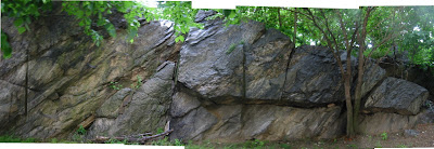
JW and I went out today to try some exploring/leading on the Expressway cliffs. JW went up about 1/2 way and down climbed due to a serious lack of gear placement opportunities. He tried several routes, by traversing across the various ledges directly above the BMX in the picture in my previous expressway cliffs post, but all were lacking, this might be a top rope-able section, see below.
I lead, an awesome little route, tuck away behind the trees, by a blackbirds nest.
Blackbird crack (5.5): Start at the slab/arete 10 feet left of the bridge wall. Climb the slab to gain the diagonal crack. Follow this crack over several bulges to a small jutting nose, level with the bridge railings. Continue up and right of the smallnose, still in the diagonal crack, to the top.
Blackbird direct(5.5)*: As above, but follow the vertical crack up (in the blasthole) left of the small nose, to the top by the huge (double) nose. There are some excellent jugs and a fantastic top out this way.
Both routes are continuous 5.4 with maybe one or two 5.5 moves. They could easily be top-roped, we used the park fence and a small tree as an anchor.
A few notes: Access to the top of the cliff for top roping other routes, is easy. From 178th and Amsterdam go up the small boulder/wall and follow inbetween the 2 fences for maybe 20 feet and there is a break in the iron fence, on the left, allowing for direct access above the cliff. Be aware that there appear to be several homeless camps at the opposite end of the cliff from blackbird, near the 175th st freeway exit.
Also JW and I were climbing in the morning/mid-day and the sun was directly in our faces, this does improve during the afternoon.
Sunday, May 27, 2007
Sunday, May 20, 2007
Edgecombe North - Pics
These are overlapping photos ECN boulder. The warmup slab route is marked, with an orange line.
Recliner (5.6?) Lay back in first section right of highball
Highball (5.6+?) The highest point in this section(& all sections for that matter) climb directly up.
Rauscher Route (5.5+?) In the 3rd grass section .... description to follow.
I will mark these up on the images when I have some time.
Recliner (5.6?) Lay back in first section right of highball
Highball (5.6+?) The highest point in this section(& all sections for that matter) climb directly up.
Rauscher Route (5.5+?) In the 3rd grass section .... description to follow.
I will mark these up on the images when I have some time.
Saturday, May 19, 2007
The Maps (Ft. Tryon Park)
Ft. Tryon Park.
From the roundabout, go in thru the park gates, and take the first path on the left. Follow this down the slope and take the path that continues down and northward. The first set of boulders are at the bend overlooking Park Dr. There is a long boulder full of blastholes with a traverse and a few obvious routes. Around the bend there are 2 boulders an overhanging boulder and a high boulder with a difficult line by the arete "its a wonderful life" (1st ascent..I doubt it!).
The dotted areas are 'cos I know there is boulder (south) and cliff with bolt (north).
The Maps (Expressway Cliffs)
I desperately wanted to go bouldering today, but the rain has delayed my plans :-( Instead I rode around the 'hood scouting and taking pictures. My newest find is a 35 foot high cliff with a number of routes I want to rope up for. The only downside is its overlooking the "transmanhattan expressway" ie 95. To get there follow 175th east from Amsterdam Ave, cross the street at the 175th exit from the highway and the "north" facing cliffs are on the left. Also El Malecon, 175th St. and Broadway, has ,so I'm told being a vegetarian, awesome pollo a la brasa (rotisserie chicken) and is just 3 and a bit blocks away for a tasty post climbing feast.
The map is below and the cliffs shadow can be seen (far right just past the end of 178th st)
Here is a picture of the cliff.
There are also a few boulders, on Amsterdam Ave around 177th st.
The map is below and the cliffs shadow can be seen (far right just past the end of 178th st)
Here is a picture of the cliff.
There are also a few boulders, on Amsterdam Ave around 177th st.
Tuesday, May 15, 2007
Tuesday, May 8, 2007
The Maps (Harlem River Drwy)
Harlem River Drwy. (Harlem River Drwy @ 155th)
Description: From the 155th, Edgecombe Ave. and Harlem River Drwy intersection, head down towards FDR/Harlem River Dr. Multiple sites.
1st; next to the sidewalk, clean.
2nd; Stairway Cliffs, under and next to the disused stairway, grassy/dirt landing, with mid-level glass. Dirty walls (bring a brush) and needs a bit of weeding, but fun.
Flare Stair(5.6?): Follow the flared crack up.
The Other One(5.7?): Follow the other cracks up
Detritus (5.7?): The slab under the stairs, next to the cracks.
3rd; Dripping Wet Arete area. The high and obvious slightly overhanging face and arete, next to sidewalk.
Dripping wet arete (5.9/10?): I can't wait to climb this awesome looking line. Water dripping on the arete and face, but hopefully this will dry up in the summer.
Overhanging face has a route too, hard, top half really hard? and there is an easy line up the crack in the corner to the left of the face.
4th; Bit further down. Clean and right on sidewalk.
Beaware of the traffic at these locations. The cars are coming off a highway and drive like it! Falling stoopid may land you in on coming traffic.
On the opposite side of the road there is a fenced off area, long and low boulder with huge pile o' trash at the bottom. Worth it?
Better map coming soon.
Little Park? Boulder (Edgecombe Ave. and 157th)
Small, not very interesting boulder with 3 easy routes. Highly painted and slippery. low-mid glass. landing sidewalk-ish?
The Maps (J Hood and Loony Bin)
J. Hood Wright Park (North West corner @ Haven Ave.)
Description: On Haven Ave. north of 173rd St. is a small 20 yard section of cliff (partly overhanging), 15 feet high. In the past have cleared all the vegetation off the rock and it is clean underneath. Glass is mid to high. Unfortunately there is a fence about 1/2 to 1 yard from the face, Pad and spotters are important for not impaling yourself (although falling on a fence can give you an awesome scar).
Loony bin South* (Riverside Dr @ 165th)
Description: A 10 foot boulder, 8 yards long facing 165th at the junction wtih Riverside Dr. Huge stepped overhang. Sandy/dirty landing with mid to low glass count. Clean.
Loony bin North* (Riverside Dr ~250m north of 165th)
Description: Walk north on Riverside Dr. from 165th, under the "skywalk", and across the intersection. The grassy area to the left contains this 20 yard - 20 footer, with mid-level glass. Clean, with a little dirt here and there may require a little weeding. Nice, different styles, cracks, slab and high up overhang.
Ride the wave (5.8?) - shite I forgot how/where it starts, ends by traversing up and right across the 3 or 4 bulging slab features.
Obvious Arete - the name says it all.
PiLlAbOx - into and then outta the large gap by mantling alone.
[* Sorry but I had to name just one location something more than the street or park name]
Sunday, May 6, 2007
The Maps (Edgecombe)
Here are the rocks (I've found so far) in Washington Heights, some of them I've climbed on, some not. When I head out bouldering next time I will take pictures for topos. But for now here are the locations (with thanks to Google maps):
Edgecombe North (Edgecombe Ave between 162nd and 163rd)
Description: A 70 yard long mostly vertical "cliff" with the height ranging from 10-16 feet. There are blast-holes every 6-8 ft, occasional graffiti/painted over patches and the rock its self is clean, and the top out is perfect.
The cliff is divided into section by three bays containing benches and direct sidewalk access. Between the benches are fenced off grassy patches with a low to mid glass count, so bring a Pad. The fence is at least 2 yards from the cliff so low collision likelihood.
The number of lines to climb here is as far as your imagination can take you. And its not just for the 'rdcore, there is a ton of easier routes too (5.6, 5.7 etc).
Warmup Slab (5.5+?): On the far left, just round from the vertical face is a small 3 move slab, that can be as difficult as you want it to be.
Playground Boulder
Just left and behind Edgecombe North facing the playground is a small, 8 foot boulder surround by some grass. It really only contains an easy slab climb in the middle (using no obvious holds/cracks) called Spiderman (shouted at/to? me the day sequel 3 was released)
Edgecombe South (Edgecombe Ave between 160th and 162nd)
Description: The south cliffs are a little higher than their northern neighbor, maybe 15-20 feet in places. Again direct sidewalk access (in the central section) plus 2 yard of low glass :-) grass. The climbing is vertical and the top out is rounded, with mud and grass, ie. not so fun. Also it's a parks and recs "house and garden" so access once on top might be problematic. Again some paint and graffiti, but the climbing is excellent. At first glance the lines are not as obvious as those of the north cliffs. But a close up inspection, reveals numerous smallish crimps and smears.
Shoot the Moon (5.7): Start directly below a crescent and blasthole in the central section, climb to this crescent and then move left and up to finish.
Blast the Moon (5.6): Start as with shoot the moon and at the crescent move up and right into the bottom of the blast hole/undercling. From here go straight thru to the other end of the blast hole and up to finish.
Either side of the central section, described above, are "fenced off" areas, with high weeds/small trees. The fences are broken in places for access. I have not yet climbed here.
Edgecombe Backside (Edgecombe Ave between 162nd and 163rd)
Description: On the far side of the Playground Boulder is a sloping rock down to a small dirt path. Along this path on the right (or possibly the left) is a small section of rock 10 yards long and 10 feet high. Looks climbable but for the spray paint, high glass count and general sketchyness of being out of sight of the road/park.
Here goes nuthin'
O.K. So what is this blog all about. Well, I'm a little bored by the bouldering in CP and wanted to find new and interesting routes. Something a little closer than the 20 minute A train ride to 59th to get on some outside rock. And don't get me wrong I like cat and rat rock but I want more. And I know there is always fort tryon park, CPW cliffs and worthless boulder but I want more climbs, more lines and something I get to discover and figure out, like a little kid in a candy store for the very first time.
If you want to know more about CP bouldering, see the "Lester LeBlanc" - A Climber’s Guide to Popular Manhattan Boulder Problems
My aim is a simple one, to catalog the bouldering in and around my 'hood, washington heights, with maps, directions, pictures and route descriptions. With the vane hope that I can get NYC climbers informed and climbing on some F#$%ing stella rock.
Now, there are 3 issues that arise, firstly access, I have no idea about access to any of the rocks I will be posting about. I am contacting city climbers club since they negotiated "climbing access issues in Central Park" back in the day. Secondly, I know people have climbed up here before but I have no clue to the history of these rocks. So I will be happy to update names, history, routes (new and old alike) if you tell me. I would like to remind you that these cliffs/rocks/boulders have not seen regular traffic and some holds may not be weight bearing, so be careful.
A word on Ethics.....
1) If someone (in uniform) ask you to stop climbing somewhere in the city, do so. Contact the CCC about the access issue afterwards, do not argue.
2) Do not climb on any bridges, walls, tunnels etc. It has the potential to cause problems with access and people don't like the little white smudges everywhere.
3) This is a little less serious than the last 2 but I wanted to put it out there. Some sites have man made blast holes, I generally only use the natural features, unless noted in the route description. On the flipside a blast hole only route can be extremely challenging and fun.
And last but not least, a disclaimer;
"I (and this blog) do not presuppose or grant permission to any persons to climb in New York City or any of the areas described within. This blog is only a reference to climbs that have been established recently. The author, in writing this blog, does not assume any liability for injuries, penalties or fines incurred by any persons attempting to climb at any area described or not described by this guide or anywhere else in New York City.
ROCK CLIMBING IS A STRENUOUS AND DANGEROUS ACTIVITY. CLIMB AT YOUR OWN RISK."
Subscribe to:
Posts (Atom)